Showing posts with label adventures. Show all posts

Thursday, July 17, 2014

Journey Across The Pamlico


The Pamlico Sound is the largest lagoon on the US east coast.  When Italian explorer Giovanni da Varrazzano reached the Pamlico Sound in 1524 he thought he was in the Pacific Ocean.  His report caused many errors in the naming of places on the map of North America.  Its vast size and numerous shoals present many dangers and rough ocean conditions.  For 2 years Lee endeavored to lead a kayak trip to cross the Pamlico Sound.  Such a trip would carry with it dangers inherent in an major open water crossing.  A paddler would have no place to bail out, rest, perform repairs, and have no shelter from storms and high winds.  The trip would also require a reliable weather window and excellent navigation practices.   In 2013 the time for the long anticipated trip came, but risky weather forced Lee to cancel the trip entirely.   He scheduled a second attempt the following year on July 12th, 2014 to leave from a public boating ramp at Stumpy Point on the mainland and cross the Pamlico Sound to the town of Rodanthe on North Carolina’s Outer Banks and return in the next 2 days when the weather permitted.  We estimated the crossing would be around 18 miles each direction with each crossing lasting a duration of 4.5 - 6 hours.  Our destination was Rodanthe Water Sports campground on the sound front and accessible directly by our kayaks.   To bolster our navigational tools, Lee studied surrounding landmarks that would be visible far out at sea.  He noted our destination was next to a water tank and near a radio tower.  He estimated the towers would be visible once we were 5 miles from shore on a relatively clear day.  Lee also picked out landmarks at our departure site to aid navigation home.  A water tank and a cell antenna a mile inland were the only distinguishing landmarks that could be seen 
at a distance for the return trip.  In preparation, I created two routes and downloaded them into my GPS a few nights before departure.  Lee had briefly contemplated leaving for Rodanthe from the port town of Engelhard which would  ve been an open crossing of 28 miles instead of the 18 miles we had planned if we had a south-west wind pushing us the entire way.  However, the winds that day were to be 10-15 mph from the north-east .  So we decided to depart from the originally planned site at Stumpy Point and deal with the wind and waves on our left beam.


Our departure point from the mainland was a wildlife
 ramp on a swampy rural hook shaped peninsula named Stumpy Point.  There were no stores or lodging facilities for 20 miles, so we staged our trip from the near by town of Engelhard which was dealing with a cleanup after hurricane Arthur passed by a a week earlier.  Mosquitos were everywhere, so the marina we had planned to camp at seemed even less inviting.  Soon after we arrived in Englelhard, we learned Chris would be meeting us at Stumpy Point for the departure.  On a whim, Lee and I decided to abandon our campsite plans and stay at the Hotel Engelhard overnight where we enjoyed good company and a hearty hot breakfast the next morning.    We started our day at 6:00 am and left for Stumpy Point after our hearty breakfast for a planned 8:00 am launch.  Driving the lonely road to the launch site we left civilization behind and contemplated the trip ahead as we stared into long empty road across a flat treeless landscape.  Chris was at the boat ramp as we arrived to begin the careful packing process of loading our kayaks for the trip.  Everything we needed along the way had to be easily accessible from the cockpit of a pitching kayak since we would not stop or get out of our kayaks until we landed in the Outer Banks.  All my food was in small plastic containers so I could grab them quickly from my day hatch.  I rigged 2 hydration systems with tubes inches from my mouth.  A 3 liter bladder strapped behind the cockpit, and a secondary 1.5 liter bladder inside my PFD.  I 
was not to use the water in my PFD until the 3 liter hydration unit was empty since it was my emergency water supply in case I was separated from my kayak and lost. I had both a VHF radio with an emergency location system and a SARSAT Personal Location Beacon.  I also carried 4 flares and a signal mirror in the front compartment of my PFD.  Attached to the side was my trusty whistle.  As we packed the NE wind penetrated the trees to remind us that this was not to be a calm day.  I worked hard all winter perfecting a bomb proof roll recovery at the pool and practiced often in the lake and during trips to ensure a good chance of recovery in the event of a capsize. 


We departed for our crossing at 8:45 am under the
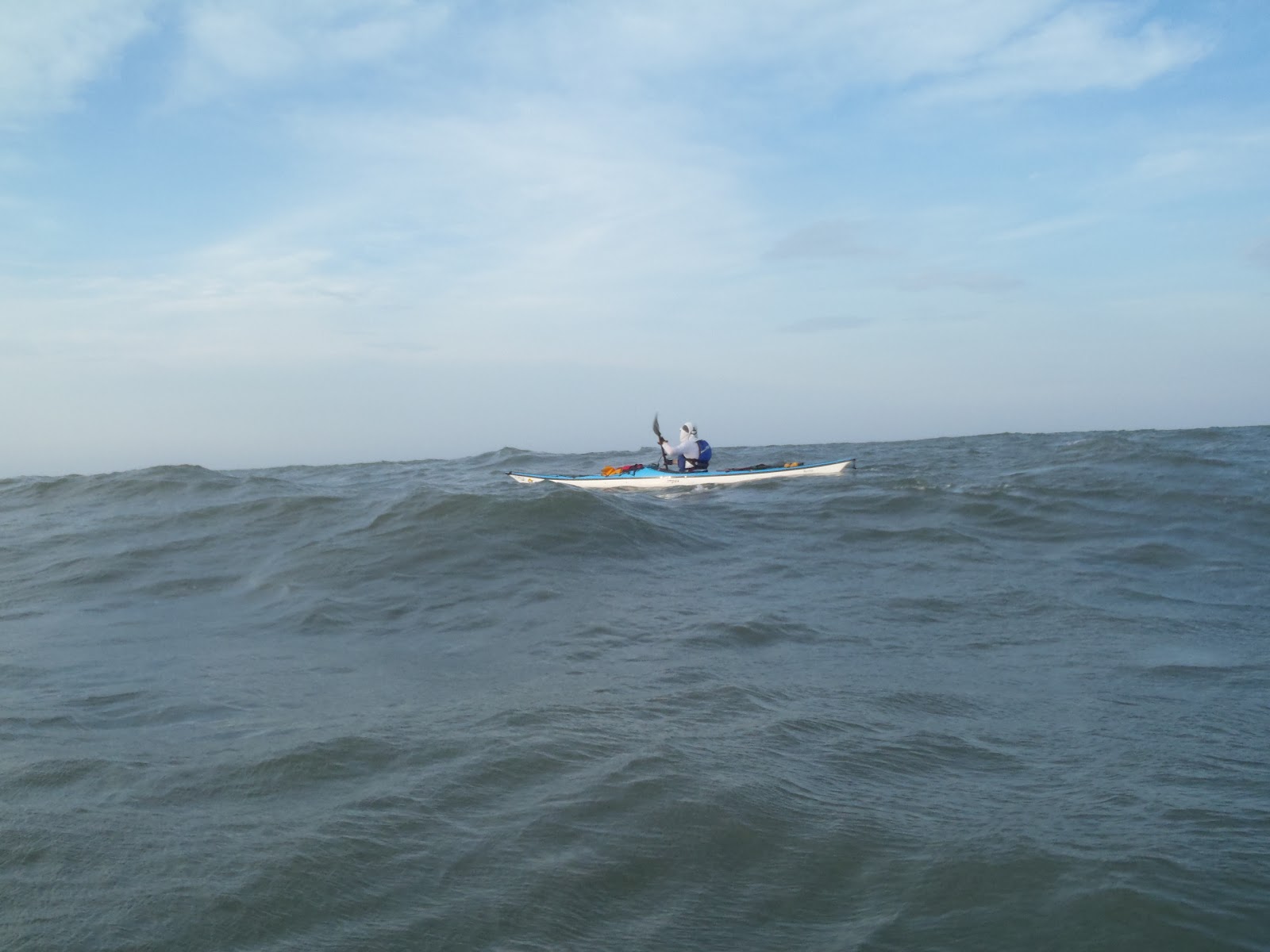
morning sun through the tranquil waters inside the hook of Stumpy Point heading toward the point.   When we reached the point, the wind and waves were waiting for us as our kayaks slammed by the 1 ft chop on the left beam.  Once around the point, we set course to the town of Rodanthe on the Outer Banks far over an empty horizon.  The water flew over our kayaks, accented in gold by the morning sun.  For the entire trip each way I had my GPS route pointer displayed page.  Once my kayak was on course, I immediately took a compass bering to our destination in case my GPS should fail and checked it periodically along the way.  For the trip over we held to bering 120 degrees.  I found the compass was easier to steer my kayak by as the GPS screen was slow to correct 
 at times to the pitching kayak which made the route pointer seem to point erratically.   The waves and wind made their presence known as waves crashed into the port side of our kayaks and spilled over the deck.  My normally less stable kayak was a little bit more stable with the kayak loaded with gear and fresh water.  Despite the waves and wind hitting us, we were making way at a good 4.2-4.7 mph as our bows pitched over the waves.  The morning sun reflection from the waves and flying spray was beautiful.  With the pitching, we had to remain vigilant about staying on course with no visible landmarks to guide us.  Lee stressed that we should err our path to the
north to counter the inevitable southward drift of our kayaks caused by the wind and waves on our left beam.   I adjusted my paddle cadence to match the period of the waves to ensure my paddle was in the proper bracing position at all times to prevent a sudden capsize.  Lee periodically looked back to determine how far out from shore he could see our return trip landmarks.   As we moved beyond the sight of land I became more comfortable relying on my navigation instruments. 


At 4.5 miles out we sited the tall water tank next to our destination which was our landmark from the outer Banks.  Our kayaks pointed strait at the landmark as it was first sighted  reassured me my navigation instruments were spot on.  From then on we were able to visually navigate as we were most comfortable doing even though we were still a long way from spotting land.  The wind was a little stronger and the waves steepened as we were far from any shore.  As the trip wore on, the miles seemed to tick off slower as our landmark so far away was in no hurry to move closer.  We could not stop, so everything we did had to be accomplished very quickly and deliberately.  Every time a hand was taken off the paddle left us vulnerable to being knocked over by one of the constant barrage of waves hitting our beam.  Through the entire trip we always gripped our paddles firmly by at least one hand.  This trip was only the second expedition for my Epic Kayak and the first in rough water.  I found accessing my food more challenging than anticipated.  So I had to curtail my meals until the seas subsided enough to safely reach for my food.  The resulting loss of calories would later catch up with me. 


As we drew closer, we could start seeing more land features.  Radio antennas appeared from obscurity, later houses, business, and other land features appeared and at long last land.  The NE wind hitting us from the side all day was coming directly from the Atlantic, so as we drew closer to the Outer Banks the shrinking fetch lessened the size of the waves.  We could feel ourselves getting closer to the Outer Banks.  The beautiful sand dunes from the national seashore painted the island with a sparkling stroke of gold.   We saw navigation markers to the Oregon Inlet pass by as we directly headed to our destination.  Having no been able to replace the energy I lost was starting to take its toll and my pace slowed considerably
as I began to struggle the last few miles.  As we neared the shore, our kayaks passed into shallow water and saw jet skis, standup boards and the puzzled looks of people at play wondering where these three kayaks appearing from the abyss came from.  We landed on a gentle beach exactly 4.5 hours after launch and traveled 17.3 miles.  The staff on hand was kind enough to help us carry our loaded kayaks from the water’s edge to a grassy spot at the top of the bluff.  After nearly 5 hours we arrived and were starving hungry after a non stop trip.  We wasted no time unloading and pitching our tents so we could clean up and find some much needed food.   We walked next door to Lisa’s Pizza in Rodanthe where
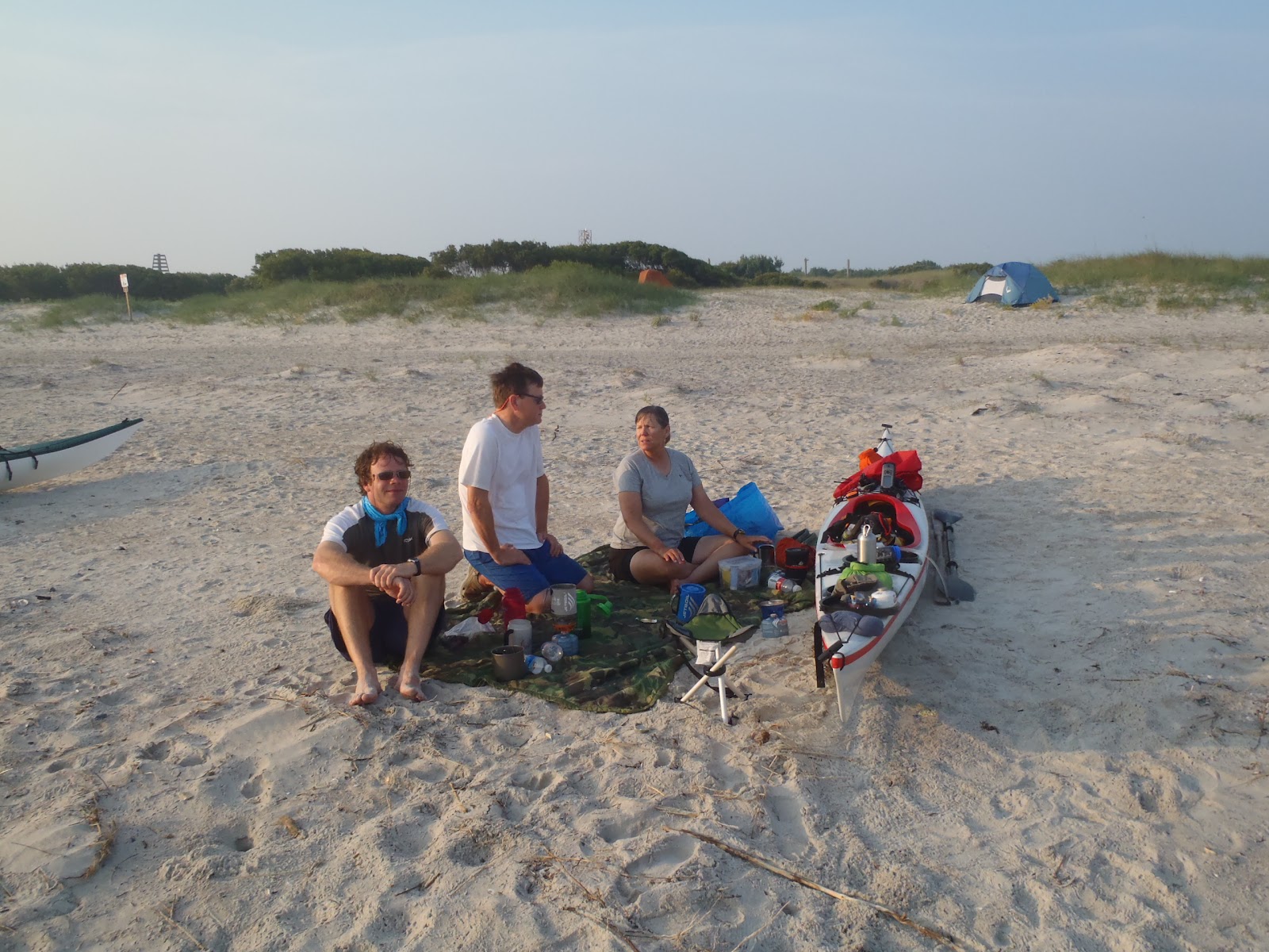
 the 3 of us ate 2 large pizzas.  After which, we sat and savored the air conditioning for a while before leaving to find Chris some ice-cream.  We hit a few shops, then walked a mile north to see “Serendipity” where the movie “Nights in Rodanthe” was filmed.  The house had been moved from its romantic spot at the ocean’s edge to a safer lot inland.  We made our way to the beach and took in the sights of the beautifully quaint Rodanthe beach for a while and made our way back to the campground in time to watch a most beautiful sunset over the Pamlico Sound.  Before going to bed, we made preparations for a very early departure back the next morning.  This would be our only weather window since the
weather was forecast to deteriorate after noon.  For my part, I hoped and prayed for a calmer less rocky trip home.  After plugging in the route back on my GPS I started getting ready for bed.  We had a most exhilarating and satisfying day and slept well that night. 


The following morning, we departed Rodanthe at 7:15 am in crystal calm conditions.  The golden light of the sun cast a warm glow as we departed familiar surroundings into what appeared to be the imaginary realm of a dream where the sky  water were indistinguishable and objects real and imaginary appeared before us.  Waves at a distance refracted off the horizon and appeared as land before vanishing.  Clouds reflected off the water looked like a continuous sky above and below.  The silence was peaceful, but its emptiness lent it to a most surreal environment we passed into.  There were also the familiar sights of pelicans plunging after fish.  Once again we started with no landmarks and relied entirely on our navigation instruments.  I took my compass bering for the trip back across the sound .  We followed herring 300 back as we plugged forward through the dream like landscape.  We spotted many unexplained objects and anomalies.  What looked like a big block of pilings or a barge ahead of us was likely trees far over the horizon magnified by the air at the water’s surface.  As we paddled on, the tranquil conditions continued.  Unlike the trip over, we could actually converse in a normal voice as we found ourselves truly alone miles from anywhere. or anything.  We spotted a red marker on the same bering as our destination so we used it as a visual landmark knowing it was stationary, but not really knowing what it was until we were almost upon it.  It turned out to be a channel marker to the Oregon Inlet.  Once we passed it we once again navigated by our instruments until at 12.7 miles into the trip, we spotted our Stumpy Point landmark on the correct compass bering and backed up by my GPS route pointer. But It was very far away and we were a long way from spotting real land.  When visibility improved, we saw the lonely Bodie Island lighthouse to the north at a distance.  We were able to make our way back 
faster with the calm conditions and afforded more freedoms
to leisurly grab for food, drinks, lotion without worry of a capsize in rough waters.  But there was little to no wind to cool
us.  At one point Lee left his kayak and took a quick swim. I


considered rolling my kayak, but did not want to get my camera wet. 


After more miles ticked off, we could see tree covered
 land and soon after, a 5 mph South East wind kicked up.  As drew closer to our landmark, I noticed my GPS route pointer starting to diverge.  We were heading for what appeared to be the point just left of our landmark, but my route pointer was continuing to diverge.  I soon realized we made the error to use our landmark as a spot on marker for our destination when in reality,  it was a mile or so from our destination.  We corrected our course to my route which I set to a waypoint at the tip of Stumpy Point.  Finally, the end was near and the wind was picking up as though the Pamlico was not willing to let us go without a fight.   But soon we rounded the point and entered the protected waters inside the point and leisurely paddled the calm last quarter mile to the ramp and the end of our trip, arriving back at 11:35 am.  Very shortly after our return our weather window closed as we observed torrent water from where we came with numerous whitecaps. 


Over the two days of this trip each one of us had paddled the farthest we had ever done without stopping or setting foot on land. We had traveled 35 miles according to my GPS at an average of 3.7 mph.   I had learned much about navigation and the importance of researching landmarks in preparation.  Preparation will make your trip much easier.  I also was reminded of the importance of replenishing the calories burned.  Toward the end of the trip over, I found myself running low on energy and struggling near the end.   Know your body and give it what it needs.  We had a great time on Rodanthe and enjoyed good food.  The passages we well planned went well with no evil surprises.  Our passage home was a surreal experience at times.  One I have never experienced before.  In summary, we were rewarded with a intimate perspective and experience that only a kayak can offer: to be one with every nuance of the sea with a front row seat to her vast emptiness, might and brilliance.     


Equipment:
Kayaks:  QCC Q700X,  Epic 18x,  P&H Bahiya

Wednesday, November 21, 2012

Kayak Katamaran Kabana
10/25/2012


I am ever in search of the perfect camping solution for different situations, and a recent post by FastYak on the CKC forum shook loose some ideas I had about a floating camping set up. I'm not thinking of a pontoon boat or a platform with flotation that could be towed by kayak to the location of one's choice. My idea is similar but more compact, which is appropriate for a small boat. 

Mountaineering and the relatively new sport of tree climbing/camping make use of suspended sleeping platforms or portaledges like this.  I have no idea how they transport the things but am assuming they don't climb up the wall or tree with the fully assembled platform hanging off their backs. Presumably it comes apart like a tent and can be stored more compactly. 

The thought of sleeping suspended that high is absolutely terrifying to me.  Being wide awake is no more comforting. I can barely even stand to look at the photos. However, the platform, minus the suspension straps is an idea that could possibly be modified for paddling. 

Such a kayaking platform would consist of two side poles and a spreader bar on each end (or vice versa) between which some kind of taught strong fabric is strung. The whole thing would be securely supported across the back and front decks of two kayaks (the "pontoons"). To get an idea of how the crossbars might work have a look at this photo of two double kayaks attached together like a catamaran for use with a Balogh Sail. For the Kayak Katamaran Kabana there would only be 2 crossbars. There would be some permanent mounting base on the kayak to which the poles would be attached. Pole length would be determined by the desired size, structural requirements and engineering limitations of the materials. The longitudinal bars would of course have to be attached in some way to the crossbars.

It could be a camping platform, sun deck, swimming/diving/fishing platform, etc. A tent could be erected on top. To reduce weight and bulk it might even be possible to use strong specially constructed paddles for 2 of the poles with those also serving as the spare paddles. Other dual purpose features could possibly be incorporated as well. Perhaps a folded configuration of the fabric could double as a sail with poles or pole parts serving as mast, boom or spar. Also, in heavy wave conditions having the two kayaks securely attached to each other could provide additional stability, more like a catamaran. 

If designed right it could be taken down and the fabric stowed in a hatch with the poles stored on deck as are spare paddles. Since 2 kayaks are needed for support there will be 2 kayakers who need a place to lay their heads. So a double platform like this Black Diamond Cliff Cabana would be needed.  For mountaineering these platforms must be over-engineered for strength given the consequences of failure. That also makes them heavy, the Cliff Cabana weighing about 20 pounds. Seems to me a kayak supported platform would not have to be that heavy. 

Has my imagination run wild? Probably yes. But it would be so cool to have a Kayak Katamaran Kabana - paddle over to a unique corner of the marsh or swamp, drop anchor or tie off to a tree, set up the platform and spend the night gently rocked to sleep on the water.

Any mechanical, structural or materials engineers out there with any ideas about how to do this?

Friday, November 2, 2012

Fifty Miles By Sea


I posted the entire article of our June 2011 50 mile ocean expedition.  From my experience, this was one of those few trips in the life of a paddler that fundamentally changes their perspective of their place on the water.  On the first day, our group encountered the roughest ocean conditions we had ever faced, far beyond our comfort zones.   As we found our place in the landscape of these hostile waters, I learned to work with the dynamics of the sea to paddle with greater confidence rather than fight and react to the relentless pounding of the waves.  In a later article I will cover what I learned.  I hope you will enjoy our story. 

On the final weekend in June 2011, 5 paddlers came together to fulfill a longtime dream for one.  Lee had long envisioned an ocean paddle expedition on the Atlantic from the banks of his house in Swansboro, North Carolina to the most eastward extent of the shoreline at Cape Lookout,  Into a notorious region known as the "Graveyard of the Atlantic" for its legacy of storms, battles, pirates, and many shoals causing unusually nasty waves having wrecked more than 2000 ships and boats of all types over the last 400 years.  Much of the region along the Shackleford Banks has changed little in 400 years.  Lee was anxious to complete the ocean paddle to take care of "unfinished business" from a similar failed expedition last year, where strong storms kept us off the ocean and hunkered down on an uninhabited island. Lee invited four additional paddlers : Dawn, Barrett, Chris, and myself.  All quite experienced.

Late afternoon on June 24th, we began to stage our expedition from Lee's waterfront back yard two miles inland. At that time strong winds were blowing and the pounding surf at the beach could be heard all the way from the sea.  All were anxious that night knowing in just a matter of hours, we would be facing the beast head-on.  I suggested driving over to Emerald Isle to scout the inlet.  Dawn said "if you do, you won't go".  The surf was forecast to be very high with five to seven foot seas the next day making surf landings difficult and risky.  That evening, we carefully and creatively loaded our kayaks for the possibility of not returning to shore for the first day's 32+ mile duration. Also, everything needed during the day must be within arm's reach and must be quickly accessible so you are not off your guard when hit broadside by a breaking wave. The task ahead was daunting.  Leave through the Bogue Inlet at low tide in the face of rough seas crashing against its shoals, paddle over thirty sea miles, before entering and crossing one of the busiest inlets on the east coast before reaching our campsite on the Shackleford banks. If the Beaufort inlet was too dangerous, we were prepared to cross in front and paddle nine more miles to the safety of a natural harbor at Cape Lookout.  An early departure at sunrise was planned. Over the night, very little sleep was had as we listened to the crashing waves from our beds. In my case anxiety got the best of me.  All of us knew to reach tomorrow's destination would summon every bit of our skills and take a bit of good fortune.

The following morning at 5:55 am, five kayaks set off for the inlet under the promise of a golden sunrise.  The wind had diminished and I felt better sitting in my kayak, satisfied with my preparations and was anxious to get started.  We made our way toward the inlet in good spirits, crossing the ICW, and skirting Dudley Island.  The sound of the crashing breakers grew louder as we drew closer to the inlet.  As we passed between Emerald Isle and Bear Island, the breakers showed their teeth as the tide drew us closer.  We remained tight in formation so we could communicate, and searched for a clear passage to sea.  There was none. Inlets naturally form shoals from the sand carried in and out with the tidal cycles forming a sometimes hellish gauntlet of breakers.  We could not see what the seas were like behind the shoal break, or new how far out the breakers went. So our plan was to hug Emerald Isle and slip away from the shoal break by moving away from the inlet down the coast, just beyond the reach of the surf.  We maintained formation as we sneaked between the high island surf and the breakers from the shoals.  But all too soon, our luck ran out and we were forced to make a run to sea.  The kayaks broke formation and headed out to sea facing the teeth of the breakers head on.  We were hammered as we slowly inched our way out,  losing sight each other, as each padder was on their own until passing the last of the breakers.  Once clear, we looked around to see who made it, reassembled, and pressed on, relieved that everyone had made it, leaving the gauntlet behind us, earning our place on the ocean, and feeling the task ahead was doable with the much anticipated hostile inlet passage behind us. 

The ocean beyond the inlet was sharp pointed waves, breaking whitecaps at times, with 17 mph winds from the southeast which gave us following seas over our right shoulders the remainder of the day.  Smoother seas were forecast the next day.  The seas were very rocky. We saw no other boats for nearly the entire first day's distance.  Shaken by our passage through the inlet, we sought safety in deeper water, angling our kayaks parallel to the deep rollers on the trip out which kept the boats level as we moved away from the shore to a distance between 1.5 and 2 miles from shore.  The ocean turned from green to a deep clear blue, leaving the sediment of the surf and breakers behind.  We then turned straight east running down the coast, our speed increased with the following waves to between 4.0-5 mph.  Shaking off the turbulent start, and feeling relieved to be under way, all of us began to settle into our new environment at sea.  For the first time, we took in the views and enjoyed the splendor of the rising sun over a vast emptiness.  The sea reflecting its twisting rays on the heaving waves.  The land was far away and featureless, disappearing in the trough of the large rollers. The waves even at 1.5 miles out were blown very sharp and tall by the wind. On one occasion, I planted my paddle down, and it did not hit the water.  Occasionally, wave-tops would break over the side of our kayaks. So we spread our formation to prevent the waves from tossing one on top of another, but kept close enough to ensure everyone was safe.  Rarely, could you see everyone at one time as we constantly moved over the waves through the troughs.  We were reassured by our arsenal of safety equipment including VHF radios, satellite tracking beacons, horns, flares, and family monitoring our progress on the internet.

Anyone traveling on the ocean in a small craft will soon notice its rhythms.  Waves exist in groups of different sizes known to mariners as "wave sets".  At times, a set of waves 10 to 12 feet would hit broadside forcing us to frequently brace our kayaks.  As the day progressed bracing became more of a subconscious action.  Calmer sets afforded an opportunity to take care of various tasks, grab a fist full of trail mix, a couple of crackers, or sip some water from the hydration unit.  Each task was quickly handled since one hand off the paddle would leave the kayak vulnerable.  When reaching for food, I would store several bites in my mouth and consume the food over the next couple of minutes. I was relying on my 3 liter hydration unit to last most of the day.  When depleted, I had several bottles stored under my sea-sock in my cockpit to fall back on.  I had a bottle for bathroom breaks at sea.  My pantry was in my deck bag, as was some safety equipment during surf passages.  My Feathercraft K1 was designed for the sea, but I still worked a small safety brace in with each stroke for safety.  We were well over a mile out and the last thing you wanted to do was go over and possibly put another paddler at risk attempting a deep water rescue.  Everyone at all times kept a wary eye on the unsettled wave train for rogue waves cracking over our heads and other bothersome waves.  Over the course of first day, several waves broke over our kayaks.  Each time, we were

 quick with the low brace.
As the day progressed, the tall wave sets became less frequent and we were putting several miles behind us.  However, at 15 miles into the estimated 32 miles, the pounding of the breakers in the inlet and the large rollers far from shore had taken its toll, and Lee requested a surf landing.  Also,  Barrett's rear storage compartment taking on water.  At the time of the decision, were still 1.5 miles off shore and could not see the surf, but we all knew it would be bad, and dreaded the looming confrontation.  Two miles later as we came close to shore, the waves grew behind us.  The surf was breaking far out from the beach,  we ran the gauntlet one by one.  Lee and Chris made great surf landings.  The rest of us met with misfortune on the way in and were tossed from our kayaks.  When near shore I looked over my shoulder, and saw Barrett's kayak nearly vertically standing on its nose on a monster wave and feared for his safety.  However, he made it to shore none the worse for wear.

Despite the rough landing, we all made it to shore and enjoyed the beach for nearly an hour.  Beach goers admired our equipment and posed for photographs in front of our kayaks.  Barrett emptied his kayak and secured his hatch, and Lee was feeling much better after replenishing his electrolytes and felt able to complete the journey to Shackleford Banks.  I replenished my on-hand provisions, topping off my hydration unit with one of the two 3 liter tanks in my storage hold. We ate lunch since it was 11:00 and the only time we would touch land until the day's paddle was over after 17 more miles.  I was rather surprised how much water I had consumed at sea.  Once our break was over, we readied our kayaks for sea and launched through the rough surf which relentlessly pounded us for nearly 100 yards out.

Once more we were underway, and cruised only a 500 yards to a quarter mile from shore.  The closer proximity to shore put us more at risk for breaking waves.   Over the remainder of the day's paddle had a few narrow escapes.  We headed east passing Atlantic beach.  As we approached the Ft. Macon (a civil war fort at the end of Emerald Isle) and the Beaufort Inlet, the waves had once again increased to around 8 to 12 feet.  At this point, we were more comfortable in these seas. We were quickly approaching Beaufort Inlet (one of the busiest inlets on the east coast).  Last year when we crossed the Beaufort inlet, we felt like mice crossing a freeway.  However, this time, the rough seas left the inlet nearly devoid of traffic. But large breakers were guarding the flanks of the channel, leaving us with a choice of heading back out to sea a mile to clear the breakers and ride the 40 ft deep channel in, or sneak around the rock jetty along Ft. Macon into the inlet.  We decided to sneak in the back door.  By this time, the tide was going in and we rode it past the breakers, crossed the channel and made our way across the inlet to the uninhabited Shackleford Banks where we planned to camp.

We pulled our kayaks up to a protected beach and set up camp, relieved that we survived the paddle without serious incident, and no rescues.  We were settling in as the daytime boaters were packing to go home.  We had traveled 34 miles and had only 10 more to Cape Lookout ahead of us.  My hands were very badly blistered and swollen, resembling ground chuck.

We took a much overdue swim and prepared to cook a wonderful Fajita dinner.  Barrett and Chris had bought some thick stakes which Lee had sliced and froze the night before.  The steak and vegetables were put into a flexible cooler and packed for the trip. We carried along 2 frying pans.  I brought along my Jet Boil with an attachment to accommodate the large pans.  Lee was the master cook for the night and made simply the best outdoor dinner I ever remember having.  We walked around to the ocean side and checked out the Shackleford side of the inlet for our departure the next day, and turned in early from what was very remarkable day.  As the last of the daytime boaters left, peace and the gentile sound of the water descende on our camp site. A gentle breeze cooled the approaching evening. We were tired. The distanced paddled in the ocean was the farthest that Lee and I had ever done in one day, and was the furthest offshore any of us had paddled.

As the sun rose on sunday, we were pleasantly rewarded for the previous day's perseverance with placid glass like seas, promising smooth passage.  After breakfast, we broke camp and set off at 8:00 am for the 11 mile trip to the Cape Lookout light.  After hitting some strange currents in the inlet, the tide swept us ouclear of the inlet and into the ocean, where we set course east once again on a straight line to Cape Lookout along a featureless, barren Shackleford banks.

The 10 miles to the "Bight" (what the locals call the bay) was easy, but hot as there was no wind, and a very hot sun.  After 5 miles,  we spotted the lighthouse on the horizon amid a rather hazy sky left from long burning forest fires a hundred miles to the southwest.  My hands were still swollen and hurting from the previous day, but in consideration of the splendid day on hand, I had little to complain about. 

Finally, we entered the bight, and made our way to the lighthouse.  The whole area was crawling with day-trippers. We crossed the Barden channel and pulled up on a nice little protected beach near the lighthouse.  By that time we spotted two kayakers with greenland paddles.  Our shuttle drivers, Bill Bremer his wife Laura, who had stayed in the comfort of Lee's house, enjoying the fine restaurants of Swansboro, arrived in their kayaks from the takeout to escort us the last leg to Harker's Island.  They had launched at 10:20 after staging Lee's Van and kayak trailer for the Hour and 15 minute drive back to the start of the expedition, and arrived within 10 minutes of us at the lighthouse.

After spending some time on the Beach and eating lunch, we set off on the last leg with the long traveled ocean to our backs, we made though the Barden Inlet and past the inland marsh of Shackleford Banks where we found ourselves among the fabled shackleford horses who paid us no mind, but rewarded us with their stately presence.  After being shipwrecked 400 years ago by the spanish and surviving countless hurricanes, they seemed no worse for ware and content without anyone's help.  We followed the channel to Harker's Island where our vehicle and kayak trailer was waiting.


At journey's end we sat for a minute reflecting all we had done and the places traveled over the two days. The tide had favored us through the 4 inlet passages. Over the last 2 days, I had grown remarkably in my paddling experience and confidence.  We encountered the sea and her many wiles on her terms of which she afforded us safe passage, allowing us to experience living on the edge out at sea as countless mariners before, and wind down with a splendid placid journey on one of the Atlantic's most beautiful coastlines and marsh. Seems hardly possible two days could be enough for all we have done.  However, the lasting effects, of what we have learned and experienced these two days will carry forth for a lifetime.
  

Copyright 2012 Lyman  A Copps